The cost of a pathway not only includes the monetary cost of building the pathway but also includes the travelling time, environmental and social impacts that ones will face when using the pathway. Cost distance analysis is useful in deciding to find the most efficient and effective route for utilities or couriers.
Least Cost Pathway
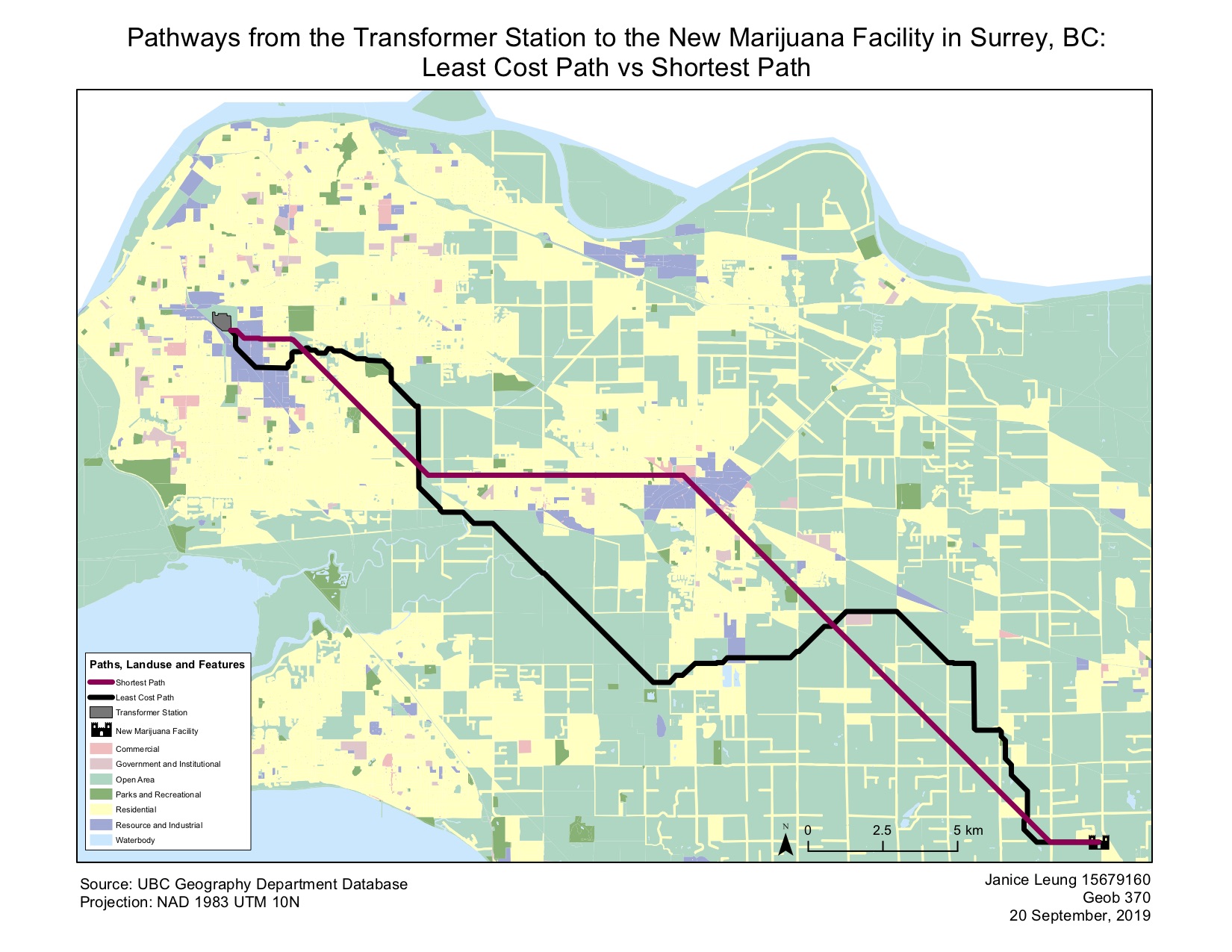
The jagged and complex route shows the most cost-efficient path to reach the new facility. This path is considered the most cost-efficient because it avoids high-cost features that will be expensive to build through. As the city is categorized by their land use types, each land use has an assigned frictional value – a value that is based on how difficult it would be to build through that area, potential travel time through that area, how much society values those areas, and other monetary costs. For example, building parts of the feeder line through waterbodies would cause major concern for some communities, increase construction costs, and involve a lot more work. Taking all this into consideration, this pathway considers all the land use types and the potential costs to build through certain areas and formulates the most optimal path to get from the station to the facility.
Shortest Pathway
The shortest path only factors in the distance, thus it produces a route that will get from the Transformer Station (point A) to the Marijuana facility (point B) in the least amount of time without considering other factors that the least-cost path might incorporate. The shortest path has no regards to whether it is built over waterbodies or residential areas, which leads to a major increase in building costs. Although it is not virtually a straight line, it is considered the most direct path to get from point A to point B.
| Landuse Type | Friction value |
| Open Area | 1 |
| Resource and Industrial | 10 |
| Commercial | 50 |
| Government and Institutional | 70 |
| Residential | 125 |
| Parks and Recreational | 150 |
| Waterbody | 200 |
The relative land use type costs were assigned according to the above friction values.
Comparing the two pathways together, to build the least-cost path it will cost $312, 250 whereas it would cost $1,635,875 to build the shortest path.
Limitations & Improvements
- Due to the conversion of vector to raster data, the representation of water features is poorly displayed and have changed in their size, demonstrating the mixed pixel problem – this is the issue in which the raster pixel size generalizes all the features within the area and assigns them one value or none.
- One way to overcome this problem can be to obtain higher resolution data or increase the resolution (reduce cell size) of the data when converting from vector to raster, so that there is less generalization. This will lead to resolution that is finer and can retain more detail.
- Additionally, one can combine the water features layers with the land use and apply a friction value acknowledging that the features exist. Another potential solution would be to use a different field model such as the hexagonal model. The six sides of the hexagon grid will allow the representation of curves better which allows the data to be seen more clearly and will not let the path diagonally cut through corner intersections of cells to avoid overlapping with high costs.
Skills I Learnt Through This Assignment
- Create an address locator for the Langley Roads
- Create a least cost path and shortest path using ArcGIS
Learning Significance