
(Don't by shy! Click to enlarge the image.)
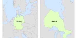
Different map projections preserve different aspects of the map. In this assignment, I made maps of Ontario and Germany on ArcMAP based on the Albers equal area conic projection.
Albers Equal Area Conic
On the map of Germany, I used the Europe Albers Equal Area conic projection to project the map. This projection best preserves the area of European countries as the standard parallels and meridian cross through the European continent. As for the map of Ontario, I used the North American Albers Equal Area conic projection to better fit Ontario as it situates in North America. For this projection, I changed the two standard parallels to 56 degrees and 42 degrees. I also changed the central meridian to -86 degrees, which is at the centre of Ontario.
Skills and Knowledge I Learnt Through This Project:
- Different properties of different projected coordinate system
- Changing the standard parallels and central meridian in Arcmap to better match the place the I have to map
Things To Improve:
- Add the projection and scale bar back on the map of Ontario