
Lab 5: Environmental Impact Assessment of Garibaldi Project
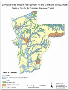
The Garibaldi at Squamish Project is about the proposed development of a ski resort, predicted to be built and finished in 2 years. It is a region of concern because the proposed area for development overlaps with many of BC’s management area. In order to visualize and analyze the environmental impacts on these zones, I highlighted the habitats of interest and found out where they lie within the proposed ski resort. The management areas being focused in this assessment are the Old Growth Forest, the Ungulates’ habitat and the fish habitat riparian management zones.
Affected habitats
To perform this assessment, I have collected data of the biodiversity that may be affected within the project area. These areas include the ungulate habitat areas, the old growth forest areas and also the fish habitat riparian management zones. I have summarized the findings in the table below:
| Area of Environmental Concern | Percentage of Area within Project |
| The Old Growth Forest Areas | 7% |
| The Ungulate Habitat Areas | 8% |
| Fish Habitats | 28% |
| Total percentage of area within Project | 43% |
Altogether, these management areas approximately take up 43% of the whole land region of the ski resort. Although the habitats do not take up more than 50% of the proposed project development, there are various other habitats that extend and are located beyond the project boundary. This means that the ski resort can indirectly and directly cause problems for all the species within the Garibaldi region.
To analyze the fish habitats more carefully, I created a buffer to determine which areas are located within 555m and below 555m. The areas above 555m were given a buffer of a 50m buffer compared to 100m - attributed to below 555m - because those areas are less likely to be of fishing bearing areas. Regardless of the number of fish bearing communities in the 50m river buffer, those fishes will still be exposed to major pollution and hazardous environments if the ski resort continues.
Errors and Uncertainty
- There are errors when I was analyzing the accumulated percentage of the proposed project land. When I added the values of each habitat individually, they did not match the values of the habitats collectively. This error is due to some habitats are overlapped with others letting the software to assume that they are the same area.
- Climate change will also affect the amount of snowfall produced each year. As this is a project that is predicted to be finished in 20 years, the calculated areas of >555m might vary and change. If there is a decrease on the >555m, this can allow more fish bearing areas to flourish thus increasing the amount of protection needed.
Skills Acquired
- Reclassified a DEM based on elevation to identify appropriate land for a ski range
- Built a multi-field query using the Select by Attribute tool to identify red listed ecosystems, ungulate winter ranges and old growth forest
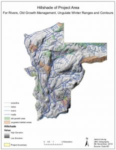
- Produced an 3D hillshade map of environmental assessment to highlight topography and slope of project area
Learning Significance